There are many reasons to visit Piatra Craiului National Park in the Romanian Carpathians only 30 km away from Brasov, one of the most biggest cities of the country. The national park is located the eastern border of the Fagaras mountains and named after its iconic mountain ridge Piatra Craiului (which means King´s rock), a 25km long limestone ridge, that is one of the most popular hiking destinations in the country. It is also home to a great variety of wildlife, such as bears, wolves, lynx, chamois, eagles and a huge plant diversity.
One of its most interesting aspects is surely the incredible scenery that you find all around the park. So, this time we decided to follow the proverb “A picture is worth a thousand words” and let photos guide you through our experience. While Hanna was unfortunately restricted due to a foot injury, Jonas had the chance to join three of the park´s rangers on an assignment close to the highest peak of Piatra Craiului. These are the photos and experiences that he brought back with him:
Starting points to Piatra Craiului
The city of Zarnesti is one of the starting points to Piatra Craiului. The beautiful visitor center (later more) of the national park is also located here and the administration was kind enough to offer us accommodation in the center during our stay. While the drive from Brasov to Zarnesti is surprisingly flat, in Zarnesti itself you are surrounded by mountains from all sides. From here, you have two choices: You either take the road to Magura village or you head straight for the stone wall in front of you. We choose the road to Magura / Pestera, from where the ascent started. No matter which route you choose, you have to pay an entrance fee of 5 Lei (ca. 1€) to access the park. This does not pay for the costs of the administration, but it shows the visitors that is a special and valuable area, where measures for nature conservation take place.The national park does not only consist of the Piatra Craiului ridge, but also encloses the village of Magura and parts of seven different municipalities. All residential areas inside the park are restricted and only sustainable development to promote ecotourism is allowed. But when we cross Magura, it seems less like a village and more like a lose accumulation of buildings due to the rugged terrain, where a few houses fit on one gentle ridge that is separated from the next houses by a deep valley.
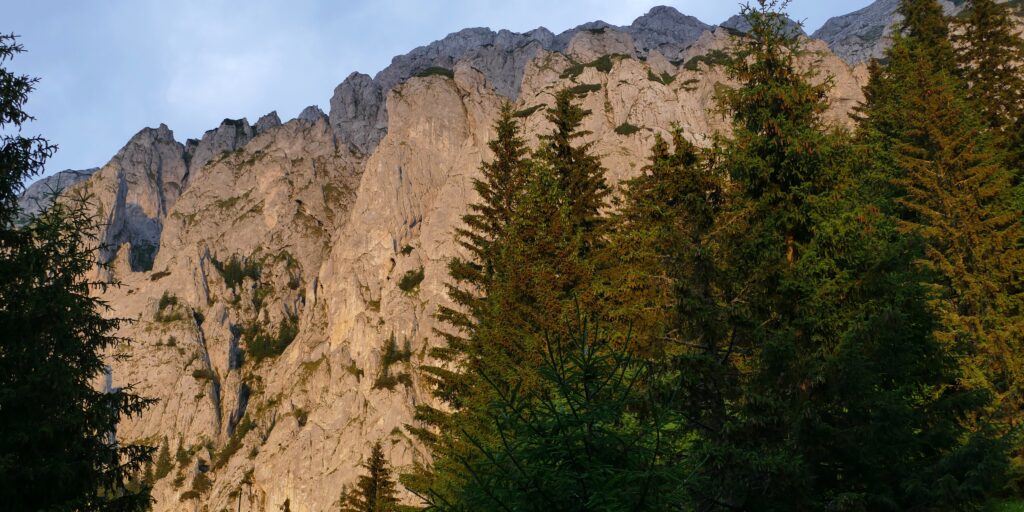
The way up
After a bumpy car ride, it is time to start hiking. The task for today is to install a new info board at the highest shelter of the park and do some small repairs on the shelter. This means carrying the approx. 1,50m wide info board and two boards to stabilize it as well as some equipment.The core zone of the park, that covers 43% of the territory and prohibits any extractive uses. In other areas sustainable land use is diverse. There is flourishing sustainable eco-tourism in the sustainable development zone in and around Magura, the forestry service conducts eco-friendly forestry in the sustainable conservation zone, and sheep and cows graze the pastures. On the way to the ridge, we pass all of the zones giving a overview of the park.The park offers seven shelters where you can spend a night for free. These bivouacs are all in beautiful locations and offer a roof over your head and an even surface to sleep on. But not much more. You must bring sleeping bag, food and water especially as the area around the ridge lacks water sources. And you have to take your waste back with you! However, at this shelter we only have lunch in the shade before we tackle the last 700m of altitude.When you hike in Piatra Craiului in summer, there is a good chance you will come cross sheep, their shepherds and shepherd / livestock guarding dogs. In summer, it can get so hot that even the sheep search for shade during the day – another sign that bringing enough water is really crucial. Nobody spends as much time in the park as the shepherds that stay with the sheep day and night, so they are important contacts for the rangers (here Remus on the left and Mihály in the middle). As we get to the ridge, the path turns steeper and rockier. I sweat like crazy climbing up in the heat of midday. But whenever I turn around to take a short break from staring at the path, I am rewarded with stunning views. The ridge is accessible from man different points with over 40 hiking trails that are over 200km long.
On top of the world
After three hours of constant ascent, we arrive at Varful La Om, the highest peak of Piatra Craiului. This is when the view opens up to all directions. In the north, you can see the fertile plains around Brasov and Fagaras separated by a lower part of the Carpathians. In the east you can see the villages that sit along the Bran-Rucar pass of the Carpathians, a historically important route between Transylvania and Wallachia. Behind the gap you can see the Bucegi mountains, which host a nature park and many recreation offers for Brasov residents like ski resorts. In the south, the Carpathians slowly descend towards their southern edge. But the most magnificent view opens towards the west, as in this picture. The wild forests of the Fagaras mountains stretch from just below you to the horizon. While you might not see them, it is easy to imagine that they are full of bears, wolves, lynx and even bisons.After a short break to recover from the ascent, the real work starts. The three rangers have to remove the old faded info board, clean the frame from rust and give it a new coating as well as install the new board. At the shelter, they fix several leaks where water got into the shelter. The maintenance of infrastructure is an important part of their work, and this was the 30th out of 31 newly installed boards within the last two months. But they also have all other kinds of other tasks from visitor guidance to law enforcement.The Piatra Craiului ridge is 25km long encompassing alpine meadows, limestone cliffs, dwarf pine thickets and heath lands. Hiking along the ridge is truly incredible due to the constant views in all directions, but also demanding as it continuously leads from one peak to the next across steep passages, over boulders and through narrow bottlenecks – all without much shade or any water source. When I see what awaits me along the ridge, my excitement grew and I decided not to join the others back to the car the next morning, but to hike along the ridge returning to the visitor center by myself.Three of the seven park´s shelters are located on top the ridge, providing the chance for an unforgettable night for everyone, who takes the effort to bring water and food for two days as well as a sleeping bag and warm clothes (at all times of the year). This is also what we do. After the long way up, it would be a pity to miss out on the sunset and sunrise on the ridge…Everyone who spends a night on the ridge has a good chance to get rewarded by this view in the morning or evening. An estimated number of around 300 chamois live around the ridge. These agile mountain dweller can easily move in the steep limestone walls, even when it is almost to dark to see anything. The best chance to see them in summer is during twilight and in the early morning, when it is still cool and they graze on the alpine pastures. When we get up around 7AM, they are happily grazing just a few meters away from the shelters and are barely bothered by us. So, we join them and have breakfast next to them.
The many faces of Piatra Craiului
Piatra Craiului is a new experience in each weather. Whether the lush green meadows glisten in the sun, low-hanging clouds make the top of the ridge invisible, the dense forests are saturated with fog after a rain shower, you see the sun rising behind the Becugi mountains or set behind the Fagaras mountains, it is always a different experience. Especially standing on top of the ridge, totally exposed to wind, sun, rain and even lightning, you see and feel how weather can change your impression in a minute.Not only the weather changes the landscape, but also the time of the day. We start the hike in bright sunshine, before a thunderstorm passes by that lifts just in time to reveal the sunset. The whole second day is pure sunshine, but the sun shining on the east slope in the morning still creates a completely different light than the afternoon sun from the west.But the beauty of Piatra Craiului does only lie only lie in the grand views over the surroundings, but also the small. It is home to 1200 plant species, many of them specific to different habitats. In spring and summer, beautiful flowers are everywhere in the meadows, between rocks and underneath trees. To be honest, I was hoping to see a bear, wolf or lynx, but this is rare – which many probably prefer. Nevertheless, the close encounters with the chamois and some little fellas were amazing.Towards the north and south the ridge is slowly descending and not covered by alpine meadows and heath anymore, but by forest. How much influence factors like exposition and gradient can have on vegetation is visible in this picture. The right side of the ridge is covered in spruce forest, while the left side is covered in dwarf pine thicket. In general, the west (left) side of the ridge is steeper leading into a lush forest below the limestone cliffs that are interspersed with small patches of grass of heaths. The east (right) side is more gentle, so sheep graze here and the spruce forest can grow further up.
A surprise on the way down
After crossing the ridge to its northern end, it is time to descend to Zarnesti again. When I start from the shelter at 7.30AM, I hope to cross the ridge before it gets too hot and then descend shaded by forest. But it turns out differently. Around 10AM it starts getting brutally hot, which makes the lack of water and shade even worse. But when I start descending around midday, I am sure it will get easier from here on. THINK AGAIN! The path down is not a gentle forest road, but a path straight down a gorge. For two hours, I scramble down on loose rocks and slippery soil, sometimes on my ass, sometimes on all fours. This was honestly the toughest descent I ever did. And I had muscle ache in my legs truly for three full days afterwards.But luckily every descent finds an end. While the Piatra Craiului ridge is the most iconic landmark of the park, there are also plenty of other natural treasures. The park has virgin forests that boast diverse and intact ecosystems and rare habitats like the screes are important for many species.After a long day in the national park, I make it back to the visitor center. The next day, we speak to Andrea and Radu about the management of the national park. They tell that one of their most important tasks is to working together with stakeholders like landowners, foresters, farmers and so on. This can be challenging when the national park has to prohibit certain things, but many also see the advantages, for example the over 100,000 people that visit the park per year. Radu tells us that managing conflicts between stakeholders is one of the main challenges in his work, but that all the struggle is worth it when he sees the natural habitats being preserved for another generation.The exhibition of the visitor center is an interactive hiking trail through the different parts of the park. You can learn about all kinds of things from the flora and fauna of the park to historic traditions and the geology. Andrea is responsible for the visitor center and tells us that her work “is sometimes hard, but this is what we have to do: engage and educate”. She loves to see the results of that, for example when children can answer her questions after a tour and workshop in the center or when she gets positive feedback.We hope this virtual photo tour made you want to experience Piatra Craiului National Park with your own eyes and feet! Apart from hiking along the ridge, you can explore the forests, cycle the super fun-looking MTB trails (but only with a real MTB), go rockclimbing in the Zarnesti gorge or skitouring in winter. We will return for sure.